Introduction
Satellites and their paths help the modern world stay close and linked. They play a big role in earth observation, communication, and navigation. When people pick an earth orbit such as Low Earth Orbit (LEO), Geostationary Earth Orbit (GEO), or Sun-Synchronous Orbit (SSO), it can change what the satellite will do. India often uses these orbits for big national and global space flights. If you learn about the earth orbit types and why they are not the same, you will see how they help us all feel closer today. In this way, the work we do with these earth orbits can also give us a strong and bright tomorrow.
Understanding Satellite Orbits
Satellite orbits let us use space technology in many ways. You can see how engineering and planetary motion work together through these orbits. There are many kinds of orbits, and these orbits can be different in height, eccentricity, and inclination. These factors decide how we get to watch distant stars or look at the earth’s surface.
Earth’s gravity is always there, helping to guide satellite systems in all kinds of orbits, even at the Lagrange points. When you look at this, you can see how science and space work together for exploration. These orbits make things like remote sensing, gps navigation, and better communication possible for us.
What Is a Satellite Orbit?
A satellite orbit is the path that a satellite follows as it goes around the earth. The National Aeronautics and Space Administration (NASA), which is also called the space administration, explains this path. The earth’s gravity and the speed of the satellite decide how that path will look. Gravity pulls the satellite toward the earth. So, the satellite moves on a set path. The way the planets move and how fast they go also change this path. The path can be shaped like a circle or sometimes more like an oval.
The type of orbit depends on a few main things. These are how high above the earth the satellite is, how the orbit tilts, and if the orbit is squeezed or stretched. For example, in a low earth orbit (LEO), the earth orbit is near the ground. A space station or a satellite here goes around the earth several times each day. The International Space Station uses this type of orbit.
On the other hand, a highly elliptical orbit (HEO), like geostationary orbit (GEO), moves with the earth as it spins. A satellite in this kind of orbit stays in a fixed position over one spot. This makes it good for things like satellite TV, as it always covers the same area on the earth. A fixed position is possible in GEO because the satellite and the earth turn at the same speed.
Inclination is also very important. It shows us if a satellite moves close to the earth’s equator or goes toward the poles. The way these technical details work together can really shape what satellite systems can do. This is very important for things like watching the weather or making global communication easier.
Importance of Satellite Trajectory in Modern Technology
Satellite orbits are the base for many things that we use every day. A lot of systems that need remote sensing trust satellites that go around the earth in a low earth orbit (LEO). These satellites let us watch the earth closely. Because of this, we get better ways to do farming, help people when there is a disaster, and learn more about the climate.
Navigation systems, like GPS, use medium earth orbit (MEO) to give us the right locations anywhere on earth. At the same time, communication satellites use geostationary orbit (GEO). This helps us get good and steady connections for satellite TV and phone calls. The way earth’s rotation and orbit work is important. It makes earth orbit systems run well and stay useful for us. Navigation systems, like GPS and geo satellites, depend on earth’s orbit, medium earth orbit, geostationary orbit, and how the earth turns.
India’s satellite missions show how to use earth orbit in a smart way for earth observation and talking to people. This is much like what China is doing in space. These plans help save money and still meet goals for earth communication and earth observation. When you see how simple it is now to connect to other people, remember that earth orbit and the path each satellite takes help make all this good technology work.
Key Terminologies and Abbreviations
To understand how satellite systems work, you need to know some key words that scientists use. Altitude is the distance from the earth to the satellite. Inclination is the angle between the path the satellite takes and the equator. These two things show how a satellite moves over the earth and what areas it can view. Eccentricity tells if the path of the satellite is a round circle or more like an oval. This helps you see if the satellite is going in a circle or in a stretched-out shape around earth.
There are some short forms you need to know for the types of earth orbit. LEO stands for Low Earth Orbit. GEO means Geostationary Orbit. SSO is Sun-Synchronous Orbit. These words show what each path is and how they are used in satellite systems. If you know about low earth orbit, geostationary orbit, inclination, altitude, and eccentricity, you will better see the work that goes on in India’s space projects and other satellite systems around the world.
Common Abbreviations (LEO, GEO, GSO, SSO, MEO, etc.)
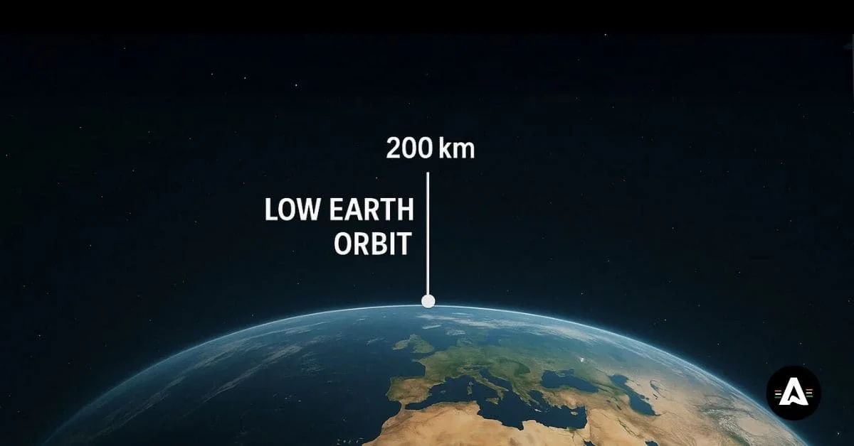
LEO stands for low earth orbit. This is when something orbits from about 160 to 2,000 kilometers above the ground. A lot of satellites be in this earth orbit. These include the Hubble Space Telescope. Some earth observation and telecommunications systems also go in low earth orbit.
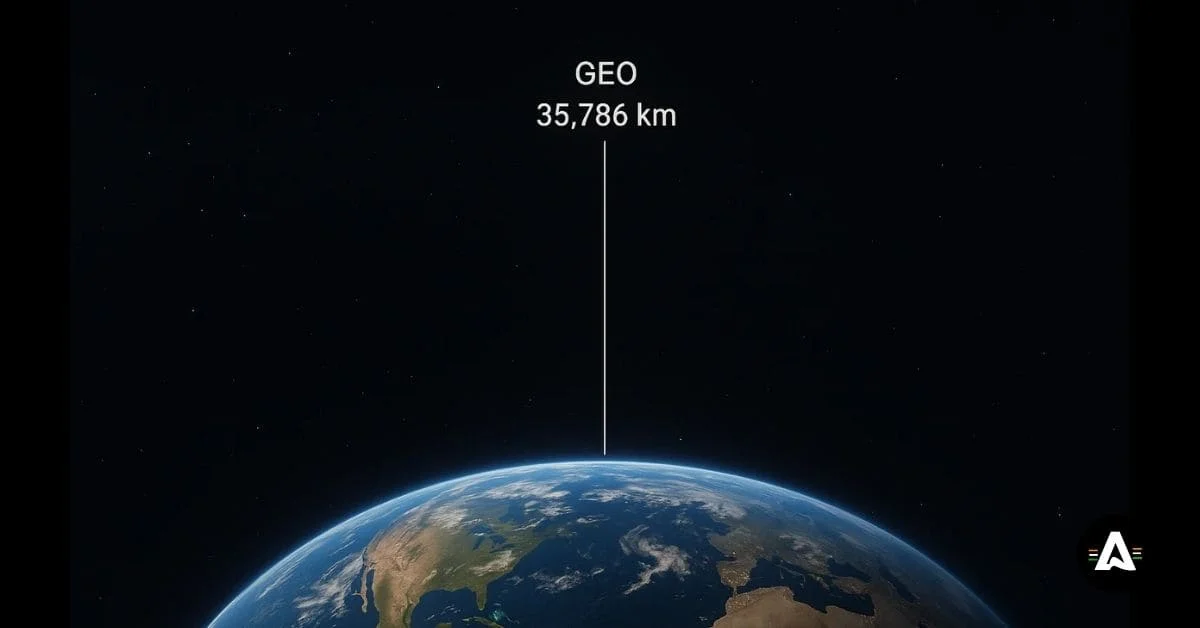
GEO means geostationary earth orbit. A satellite in GEO stays in a fixed position over the equator. This earth orbit lets satellites have a constant view of the Sun. GEO is about 35,786 kilometers away from earth. A satellite here is good for having steady links for communication.
SSO, or sun-synchronous orbit, is a type of earth orbit that lines the satellites up with the sun. This lets them get the same light every time so earth observation can be more exact and clear.
MEO, or medium earth orbit, is where many navigation systems like the Global Positioning System (GPS) are found. This orbit is between 2,000 and 35,786 kilometers up from the earth. Medium earth orbit sits in the middle, above low earth orbit and below geostationary earth orbit. MEO is important for global positioning, navigation, and the work that GPS does all over the globe.
Classifying Types of Satellite Orbits by Characteristics
Each satellite’s path around the earth is sorted into a group based on its altitude, inclination, and eccentricity. The altitude is about how far the satellite is from the earth. LEO satellites are nearer to the ground. But GEO satellites are much higher up above the surface.
Inclination is the angle a satellite’s path makes with the earth’s equator. If a satellite is in a polar orbit, it goes over the earth’s poles at an angle close to 90 degrees. This type of orbit lets people do earth observation from all over the planet. A satellite with zero inclination travels right above the equator. Eccentricity is about the shape of the orbit. Some satellites follow a round path, but others go in an oval path. The way the path looks depends on what people want the satellite to do.
Characteristic | LEO | GEO | SSO |
|---|---|---|---|
Altitude | 180-2,000 km | 36,000 km | 600-800 km |
Inclination | Variable | 0° | 98° |
Eccentricity | Circular/Elliptical | Circular | Nearly Circular |
Being able to tell satellites apart using these details can help people connect each type of orbit to its main use and goal.
Low Earth Orbit (LEO)
Low Earth Orbit (LEO) is a type of earth orbit that happens at about 160 to 2,000 kilometers above the earth’s surface. In this orbit, satellites move quickly. They can go all the way around the earth in about 90 to 120 minutes. LEO is very good for earth observation and remote sensing. This is because the satellite systems can take lots of pictures of the earth in a short amount of time.
The altitude in LEO is lower, so there is not as much atmospheric drag. This helps the Hubble Space Telescope and other satellite systems to work better. That is why LEO is such a good place to use for space projects. You can get many benefits if you want to use satellites for earth observation, remote sensing, or other work in a low earth orbit.
Features and Altitude Range of LEO
Leo is close to earth. this gives it some important features. here are the main points:
- Altitude range: These satellites fly at an altitude between 180 and 2,000 km above the earth. This lets them go around the earth fast.
- Orbital speed: To keep up with their work, they move at an orbital speed of about 7.8 km every second. This is important for tasks that need a lot of data.
- Atmospheric drag: Since they are close to the earth, the satellites feel more atmospheric drag. They sometimes have to get a push to stay on their right path.
Most LEO satellites move in paths that are round or just a little stretched. The way LEO works is good for earth observation. It gives you clear pictures, and that is helpful for things like climate study or after a disaster happens. Many satellite systems, like Starlink, use this kind of orbit. They do it so people in many places can have fast internet.
Applications of LEO Satellites in India and Worldwide
LEO satellites help bring new technology to all parts of the world and in the country. People use leo satellites for many things, like:
- Remote sensing: They use clear pictures to help farmers. These pictures also be used to help during disasters.
- Earth observation: These satellites watch forests that are being cut down. They also keep track of other changes in the environment.
- International Space Station (ISS): The space station, called the International Space Station, helps the world with science and research.
- Starlink satellites: Starlink satellites give fast internet to people everywhere. This includes places that do not have good internet service.
India also uses LEO satellite systems to support its farmers. These systems help watch the forests and keep the country safe. All of this shows that LEO is a good place for strong and flexible satellite systems in India.
Geostationary Earth Orbit (GEO)
Geostationary Earth Orbits, or GEO, are important for satellite communications. A GEO satellite stays at a height of about 35,786 kilometers over the equator. It keeps a fixed position over one spot on earth. Because of this, it can keep watching the same part all the time. This is good for things like broadcasting and making phone calls. A GEO satellite moves in a circle that matches the earth’s rotation. This helps stop any problem from things like atmospheric drag, and it helps make sure their orbital speed stays the same. With this steady path, GEO is good for weather satellites and navigation systems. They give real-time data and are very useful and reliable for people who need up-to-date information.
Unique Properties of GEO
Geostationary Earth Orbit, or GEO, is a kind of earth orbit that stands out from other types of orbits. Satellites in GEO and GSO are set around 35,786 kilometers over the equator. In this earth orbit, the satellite stays in a fixed position above the same point on the equator. It moves at the same speed as the earth turns. Because the satellite stays in the same spot, geo satellites and satellite systems can give stable communication. This is very good for weather satellites and for telecommunication services.
A circular geosynchronous orbit can help to reduce atmospheric drag. When satellites are put in this spot, they can work well for a long time. This means satellite systems can stay useful for many years.
Uses of GEO Satellites for Communication and Broadcasting
Geostationary satellites stay in a fixed position high above the earth’s surface. This makes them very useful for things like communication and broadcasting. Since the satellites always look at the same spot, you can use them to send TV signals, connect to the internet, or share radio talks with people. These geostationary satellites, or GEO satellites, are found at an altitude of about 35,786 kilometers. From this height, they can cover a large part of the earth for things like broadcasting big events to people everywhere. GEO satellites also give reliable help with navigation and remote sensing. All of this makes them very important in the ways we share and get information today.
Sun-Synchronous Orbit (SSO)
The sun-synchronous orbit (SSO) is a special type of orbit for a spacecraft. In this orbit, the satellite always keeps the same angle with the sun. This means it passes over each part of Earth at the same local time every day. This is good for earth observation, as the satellite will always see the ground with the same amount of light. So, when it takes pictures, the light does not change.
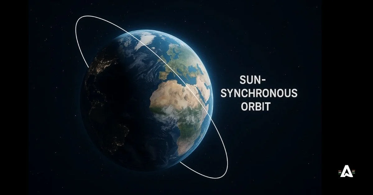
By moving to match the sun, these types of orbits help with remote sensing. The pictures and data they collect can be used for weather forecasts and to watch changes happening in the environment. Because these spacecraft travel over the poles, they can see all parts of the world. This helps us get better information from every place on Earth.
How SSO Works and Its Orbital Path
Sun-synchronous orbits, also called SSO, help satellite systems stay at the same angle with the Sun each day. This means when the satellite moves around the Earth, it will pass over the same spot at the same local solar time every day. These paths are almost straight over the poles. Because of this, the satellite can fly over all areas of the Earth, which is very helpful for earth observation and remote sensing.
This way of traveling in space helps people keep an eye on changes in the environment. It also lets us watch solar activity and see when the seasons change. A Sun-synchronous orbit allows satellites to get good and steady data from many places on Earth. Because of this, these orbits let us use remote sensing and earth observation. We can know more about our world and solar activity when we use satellite systems.
Major Applications of SSO Satellites (Earth Observation, Weather)
Satellites that move in a sun-synchronous orbit (SSO) are important for earth observation and weather checks. These satellites go around the earth in a way that keeps the same angle with the sun each time. This way, they always take pictures with the same kind of light. A sun-synchronous orbit helps a lot with remote sensing because it lets us get regular, clear images of the earth.
These SSO satellites help us make accurate maps. They show how land is used and help us see changes in the environment. SSO satellites also be useful for weather. They send up-to-date information, which alerts us about storms and bad weather. This can help people get ready and stay safe during natural disasters. They play a big part in helping people prepare for and deal with storms and other problems caused by nature.
Comparing LEO, GEO, and SSO
Understanding the different kinds of earth orbit is key for space missions. Low Earth Orbit (LEO) is close to the earth’s surface. This type of orbit works well for things that need fast moves and quick talk, because the signals travel fast. People like LEO for this reason. A Geostationary Earth Orbit (GEO) lets a satellite stay over one fixed position above the equator at all times. So, it’s good for sending out TV signals and checking the weather, because it covers the same spot all the time. A Sun-Synchronous Orbit (SSO) moves with the sun as it goes around the earth. This helps with earth observation jobs. Each type of orbit, like LEO or GEO, has its own things to think about, like the altitude, the cost, and how much of the earth the satellite can look at at once. Picking one orbit type changes how you plan the mission.
Differences in Altitude, Coverage, and Cost
Altitude, coverage, and cost are what make types of earth orbits different from each other. A low earth orbit, or LEO, is between 160 and 2,000 kilometers above the ground. Satellites in a low earth orbit give good coverage, but they move fast. Because they have a high orbital speed, they have to keep passing over the same spot on earth again and again.
Geostationary Earth Orbit, or GEO, is where satellites are put at around 36,000 kilometers above the earth. These satellites stay in a fixed position over one area. That means they keep watching the same place all the time and can cover those regions without stopping.
But when you look beyond GEO, the high earth orbit, or HEO, gives people more things to try and new problems to solve. Still, staying at this higher altitude has its price. Sending satellites up there and running them in GEO costs more than using satellites in LEO, which is the lower earth orbit.
Selecting the Right Orbit for Indian Satellite Missions
Selecting the right earth orbit for Indian satellite missions starts with knowing what the mission is for. Low Earth Orbit (LEO) is often used for earth observation and remote sensing. It helps satellites collect clear images because there is not much atmospheric drag. This means the data and pictures can be very sharp.
Geostationary Orbit (GEO) is a good pick when you need the satellite to stay in one spot over the earth. This type of orbit is helpful for navigation systems and communication. A Sun-Synchronous Orbit is another option. It works well for weather satellites because it provides steady light from the sun. This makes it easier to follow weather changes over time.
Picking the type of orbit has a big effect on how well the mission works. It also changes how much you pay and how long the satellite stays useful. The choice between LEO, GEO, or another earth orbit depends on what you want the satellite to do.
Conclusion
There are many kinds of earth orbit, like low earth orbit, geostationary orbit, and sun-synchronous orbit. Each one is used for different things, such as earth observation, remote sensing, and communication. NASA also uses these orbits for their work. When you know the features and good points of each earth orbit, you will make better choices about where to put satellites. As tech keeps getting better, these orbits will be used more in navigation and navigation systems. This will make remote sensing better, help people get global connections, and also help us do science around the world.